#EAS #WEA for In this area: Voluntary Evacuation is in effect for areas along Black River and low-lying areas. Black River crest 26.5 ft Wed. Shelter open at Pocahontas Community Center. 205 Geneva Dr. Source: 202220,,Randolph County AR OEM ** DO NOT RELY ON THIS FEED FOR LIFE SAFETY, SEEK OUT OFFICIAL SOURCES ***
Recent searches
Search options
#wea
#EAS #WEA for In this area: Voluntary Evacuation is in effect for areas along Black River and low-lying areas. Black River crest 26.5 ft Wed. Shelter open at Pocahontas Community Center. 205 Geneva Dr. Source: 202220,,Randolph County AR OEM ** DO NOT RELY ON THIS FEED FOR LIFE SAFETY, SEEK OUT OFFICIAL SOURCES ***
Besichtigt mit uns einen #Windpark!
Die #Exkursion fand letztes Jahr so großen Zuspruch, dass wir sie dieses Jahr sehr gern wiederholen. Am Samstag, den 26. April 2025, laden wir herzlich zu der Besichtigung des Windparks Zaasch in der Nähe von #Leipzig ein. Hier erfahrt ihr alles Wissenswerte über Windenergieanlagen, kommt ins Gespräch mit Expert:innen und, wenn das Wetter mitspielt, kann eine Anlage hochgeklettert werden (ab 15 Jahren)! Nebenbei könnt ihr euch mit anderen BUNDlern:innen austauschen und mit den gewonnen Infos die #Energiewende in #Sachsen vorantreiben!
Die wichtigsten Infos:Wann: Samstag, 26. April 2025, ca. 2-3 Stunden
Wo: in der Nähe von Leipzig
Kosten: für BUND-Mitglieder kostenfrei, für nicht Mitglieder 15 Euro pro Person
Teilnahme nur mit Anmeldung: https://www.bund-sachsen.de/service/termine/detail/event/besichtigung-des-windparks-zaasch/
Seid schnell, denn die Plätze sind nur auf 20 begrenzt! Weitere Infos folgen nach der Anmeldung. Wir freuen uns auf euch!
#EAS #WEA for Mississippi, #MO; #New Madrid, #MO; #Scott, #MO: National Weather Service: #TORNADO WARNING in this area until 10:15 PM CDT. Take shelter now in a basement or an interior room on the lowest floor of a sturdy building. If you are outdoors, in a mobile home, or in a vehicle, move to the closest substantial shelter and protect yourself from flying debris. Check media. Source: NWS Paducah KY ** DO NOT RELY ON THIS FEED FOR LIFE SAFETY, SEEK OUT OFFICIAL SOURCES ***
#EAS #WEA for Carter, #MO: National Weather Service: A FLASH #FLOOD EMERGENCY is in effect for this area until 1:30 AM CDT. This is an extremely dangerous and life-threatening situation. Do not attempt to travel unless you are fleeing an area subject to flooding or under an evacuation order. Source: NWS Paducah KY ** DO NOT RELY ON THIS FEED FOR LIFE SAFETY, SEEK OUT OFFICIAL SOURCES ***
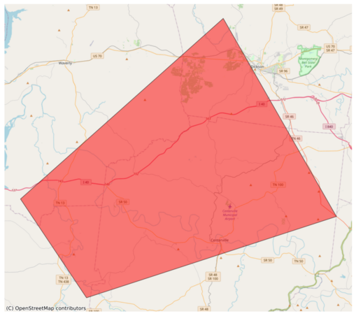
#EAS #WEA for Dickson, #TN; #Hickman, #TN; #Humphreys, #TN; #Perry, #TN: National Weather Service: #TORNADO WARNING in this area until 6:00 PM CDT. Take shelter now in a basement or an interior room on the lowest floor of a sturdy building. If you are outdoors, in a mobile home, or in a vehicle, move to the closest substantial shelter and protect yourself from flying debris. Check media. Source: NWS Nashville TN ** DO NOT RELY ON THIS FEED FOR LIFE SAFETY, SEEK OUT OFFICIAL SOURCES ***
@easwatch #NCwx #NorthCarolina #EAS #WEA for NC North Carolina Department of Public Safety: Endangered Missing Child - DURHAM, NC: Icelyn Wilson, 2 year old black male. Maybe in a White 2019 Nissan Rogue, VX51815. Last known to be on Berwyn Ave or Alston Ave. If seen, call 911. Source: 200071,NC North Carolina Department of Public Safety,North Carolina Center for Missing Persons ** DO NOT RELY ON THIS FEED FOR LIFE SAFETY, SEEK OUT OFFICIAL SOURCES ***
#EAS #WEA for NC North Carolina Department of Public Safety: Endangered Missing Child - DURHAM, NC: Icelyn Wilson, 2 year old black male. Maybe in a White 2019 Nissan Rogue, VX51815. Last known to be on Berwyn Ave or Alston Ave. If seen, call 911. Source: 200071,NC North Carolina Department of Public Safety,North Carolina Center for Missing Persons ** DO NOT RELY ON THIS FEED FOR LIFE SAFETY, SEEK OUT OFFICIAL SOURCES ***
#EAS #WEA for Davidson, #TN; #Rutherford, #TN; #Sumner, #TN; #Williamson, #TN; #Wilson, #TN: National Weather Service: A FLASH #FLOOD WARNING is in effect for this area until 12:00 PM CDT. This is a dangerous and life-threatening situation. Do not attempt to travel unless you are fleeing an area subject to flooding or under an evacuation order. Source: NWS Nashville TN ** DO NOT RELY ON THIS FEED FOR LIFE SAFETY, SEEK OUT OFFICIAL SOURCES ***
#EAS #WEA for Cheatham, #TN; #Davidson, #TN; #Macon, #TN; #Robertson, #TN; #Sumner, #TN; #Wilson, #TN: National Weather Service: A FLASH #FLOOD WARNING is in effect for this area until 12:00 PM CDT. This is a dangerous and life-threatening situation. Do not attempt to travel unless you are fleeing an area subject to flooding or under an evacuation order. Source: NWS Nashville TN ** DO NOT RELY ON THIS FEED FOR LIFE SAFETY, SEEK OUT OFFICIAL SOURCES ***
#EAS #WEA for Clay, #TN; #Jackson, #TN; #Macon, #TN; #Overton, #TN; #Pickett, #TN; #Smith, #TN; #Sumner, #TN; #Trousdale, #TN; #Wilson, #TN: National Weather Service: A FLASH #FLOOD WARNING is in effect for this area until 10:45 AM CDT. This is a dangerous and life-threatening situation. Do not attempt to travel unless you are fleeing an area subject to flooding or under an evacuation order. Source: NWS Nashville TN ** DO NOT RELY ON THIS FEED FOR LIFE SAFETY, SEEK OUT OFFICIAL SOURCES ***
#EAS #WEA for Christian, #KY; #Hopkins, #KY; #Muhlenberg, #KY: National Weather Service: #TORNADO WARNING in this area until 11:15 PM CDT. Take shelter now in a basement or an interior room on the lowest floor of a sturdy building. If you are outdoors, in a mobile home, or in a vehicle, move to the closest substantial shelter and protect yourself from flying debris. Check media. Source: NWS Paducah KY ** DO NOT RELY ON THIS FEED FOR LIFE SAFETY, SEEK OUT OFFICIAL SOURCES ***
#EAS #WEA for Clark, #IN; #Floyd, #IN; #Harrison, #IN: National Weather Service: #TORNADO WARNING in this area until 12:00 AM EDT. Take shelter now in a basement or an interior room on the lowest floor of a sturdy building. If you are outdoors, in a mobile home, or in a vehicle, move to the closest substantial shelter and protect yourself from flying debris. Check media. Source: NWS Louisville KY #Clark, #IN; #Floyd, #IN; #Harrison, #INwx** DO NOT RELY ON THIS FEED FOR LIFE SAFETY, SEEK OUT OFF
#EAS #WEA for Calloway, #KY; #Graves, #KY; #Marshall, #KY; #Trigg, #KY: National Weather Service: #TORNADO WARNING in this area until 10:00 PM CDT. Take shelter now in a basement or an interior room on the lowest floor of a sturdy building. If you are outdoors, in a mobile home, or in a vehicle, move to the closest substantial shelter and protect yourself from flying debris. Check media. Source: NWS Paducah KY ** DO NOT RELY ON THIS FEED FOR LIFE SAFETY, SEEK OUT OFFICIAL SOURCES ***
#EAS #WEA for Weakley, #TN: National Weather Service: #TORNADO WARNING in this area until 9:30 PM CDT. Take shelter now in a basement or an interior room on the lowest floor of a sturdy building. If you are outdoors, in a mobile home, or in a vehicle, move to the closest substantial shelter and protect yourself from flying debris. Check media. Source: NWS Memphis TN ** DO NOT RELY ON THIS FEED FOR LIFE SAFETY, SEEK OUT OFFICIAL SOURCES ***
#EAS #WEA for Delaware, #IN: National Weather Service: #TORNADO WARNING in this area until 10:30 PM EDT. Take shelter now in a basement or an interior room on the lowest floor of a sturdy building. If you are outdoors, in a mobile home, or in a vehicle, move to the closest substantial shelter and protect yourself from flying debris. Check media. Source: NWS Indianapolis IN ** DO NOT RELY ON THIS FEED FOR LIFE SAFETY, SEEK OUT OFFICIAL SOURCES ***
#EAS #WEA for Blackford, #IN; #Grant, #IN; #Jay, #IN: National Weather Service: SEVERE THUNDERSTORM WARNING in effect for this area until 11:00 PM EDT for DESTRUCTIVE 80 mph winds. Take shelter in a sturdy building, away from windows. Flying debris may be deadly to those caught without shelter. Source: NWS Northern Indiana ** DO NOT RELY ON THIS FEED FOR LIFE SAFETY, SEEK OUT OFFICIAL SOURCES ***
#EAS #WEA for Crittenden, #AR; #Cross, #AR; #Poinsett, #AR; #St. Francis, #AR: National Weather Service: #TORNADO WARNING in this area until 8:45 PM CDT. Take shelter now in a basement or an interior room on the lowest floor of a sturdy building. If you are outdoors, in a mobile home, or in a vehicle, move to the closest substantial shelter and protect yourself from flying debris. Check media. Source: NWS Memphis TN ** DO NOT RELY ON THIS FEED FOR LIFE SAFETY, SEEK OUT OFFICIAL SOURCES ***


